|
eLivermore.com - By Bill
Nale |
|
Livermore Naval Air Station
The Livermore Naval Air Station was at the site
where the Lawrence Livermore Lab is now. It was established in early 1942,
and closed in 1946.
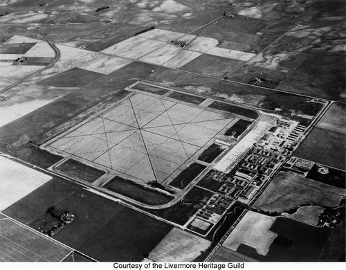
Livermore Naval Air Station airfield looking north east, with the intersection of Vasco and East Ave.
at the bottom.
Greenville road is on the far side, going from the right toward the upper left.
It crosses the WP railroad tracks near the upper left, just after the tracks
curve northward. With this square runway, it appears like
you could take off or land in any direction.

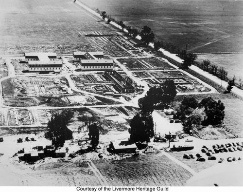
This is the buildings section of the above photo, cropped and
rotated. The road at the bottom is East Ave. Many of the building in
this photo are are still present at the Lawrence Livermore Lab.

This picture was taken from the air toward the north west, at the
eastern end of the air station. The hanger (building at top) appears in the
"buildings" photo above near the right side at the top (the darker
roofed hanger). The building in
the center of this photo is hard to make out in the "buildings" photo. It
is NOT the building at the right in that photo, but sits south east of the
hanger, and blends in with the sidewalks in the "buildings" photo. It can
be seen when zooming in on the full resolution image.
A mixture of biplanes and single wing planes can be seen near the hanger. There
appears to be a lot of construction material around.

This appears to be the construction of training aircraft.
This hanger is most likely the same as the one in the above photo. The
windows match.
Probably early 1942, during the initial construction, looking
east. East
Ave. is to the right. The airfield would be to the left of this photo.
Several buildings of this shape remain at the lab. It appears that the
building on the left is still at the lab and the one of the right is partially
there.

Cadets marching July 15, 1943. Looking west down the main
drag.
This photo is from the opposite direction as the one above it. In the
photo above this one, the flagpole would be near the upper right corner of
building on the right. That corner of the building cannot be seen in this
photo, except for the edge of the upstairs balcony, which is barely visible at
the far right at the bottom. The south east corner of that building is the
first building on the right of this photo.
The hangers would be behind and to the right, with East Ave
parallel to this street, to the left.

This parade picture was taken several minutes before the one
above. It is looking north-east. What might be serving as the
control tower can be seen behind the flag. This building is still present
at the lab. One of the hangers can be seed to its left.
Links
LLNL
History page on the NAS